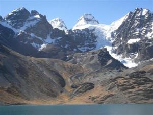
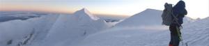
ILLIMANI AND LITTLE ALPAMAYO, BOLIVIA, EARLY AUGUST 2011
(In this La Nina year, ample snowpack was feeding the otherwise rapidly retreating Andean glaciers. Below is the Condoriri Range with the head of the condor and wings outstretched.)
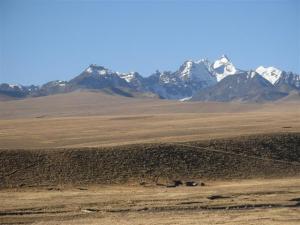
Coming overland from Peru and Lake Titicaca into La Paz, the Cordillera Real or the Royal Range stretches for more than 50 miles southward from the Peruvian border in an unbroken snowy crest punctuated by massive 20,000 ft peaks, separating the high desert plains (Altiplano) from the low jungles of the Amazon Basin.
As I sped along the two-lane highway in a dilapidated mini van packed with Bolivians and one ornery Spaniard next to me, massive thunderheads loomed ahead. It seemed there was no avoiding what was about to happen next. We quickly found ourselves immersed in a tempest of hail stones which drove visibility to near zero and turned the road and surrounding plane to a featureless sea of white in an instant. Like so many male drivers in Latin America, ours forged bravely (or foolishly) ahead, despite broken wipers and a malfunctioning windshield defroster. To my relief, he at least had the good sense to slow down. Crammed in the middle of the front seat next to the driver, my job was to take his towel and wipe down the windshield every 5 seconds (little consolation considering the wipers were already out of service). Perhaps the strategy is just to push through to the other side as quickly as possible, and this we did, coming out on dry road again not 15 minutes later (although after what seemed like an eternity).

By now, 6 PM, the sun had set on this tropical country and we plunged into the long cold 12-hour night. We bumped and jostled our way into the outskirts of La Paz just in time for rush hour and just in time to get stuck behind a melee of trucks and taxis that seemed to be faced off going neither forwards nor backwards horns honking incessantly. Eventually someone unplugged the blockage and we were battling our way onwards to the verge of the chasm that marks the descent into the canyon that holds La Paz proper. From the 12,000 ft. altiplano, we plunged downwards towards the sparkling lights of the city center of La Paz, one of the most spectacular (and highest) cities in the world. The steep streets and thin air are quite enough to deal with upon arrival, and the pollution (some of the worst in Latin America, adds insult to injury. This was the start of my 10-day Bolivian climbing adventure—a short vacation before I needed to get back to Peru to lead a study abroad course in biology for the University of Washington.
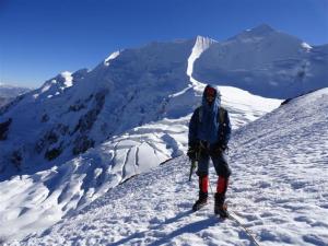
Traveling alone, my plan was to climb with a Bolivian guide, Eduardo Mamani. My main goal was the 21,200 ft. Illimani which forms the backdrop for La Paz. My available time was short (just over a week), and perhaps questionable, but previous high altitude experience told me that I would probably be OK. So, after a day in La Paz, I left immediately for the mountain to begin the acclimatization process (Eduardo would join me 4 days later). Up and down the mountain I went, every day, gradually moving my campsite upwards with each night, making friends with local herders and porters, chatting with other climbers from around the world, and learning the daily weather patterns. Clear skies in the morning would usually give way to massive clouds building on the Amazon side of the mountain, pushing through passes and swirling up the mountain in the afternoon, often with a snow squall or thunderstorm, before clearing again in the evening. Feeling good, and confident in the stability of the weather, I finally set up at high camp at 18,000 ft. on the fourth night on a spine of rock flanked by glaciers, known as the “Condor’s Nest”. As it turned out, I had actually seen two of these rare and massive birds soaring near here a few days earlier. With Eduardo here now too, the plan was to go for the summit the following morning before extended time at altitude could wreak havoc with my body. The plan then was to hydrate, eat, and sleep, but not before the ritualistic readying of the rope, crampons, and other gear that we would doubtless not want to fumble around with in the freezing wee hours of the morning.
My alarm was off at 2:30, and shivering in my tent, I forced myself to eat and drink as much as I could—3 cliff bars and several cups of warm Nuun were all I could manage. A hot water bottle went into the inner pouch of my jacket (to prevent freezing), and it was time to move. Leaving at 3:15 AM, the grating of crampons on rock, quickly turned to the quiet firmness of Andean snow, which is delightfully firm and crunchy, with pristine snowflakes from the previous day’s flurries sparkling under the headlamp. Climbing at altitude is a slow and rhythmic process. Throw into that the 10-12 degree F temps, and a stiff 20-30 mph wind, and you don’t want to stop for fear of getting too cold. I forced myself to drink water when I could, but the main focus was only on steady upward progress into the starry night. And with each 1000m gain in altitude, the progress became that much more difficult. I began imagining the painful ski marathon I raced 3 years ago in a blizzard, where each lap got progressively harder mentally and physically. I focused on pace, I focused on my breathing, trying hard to stave off the headaches that come on with O2 deprivation.
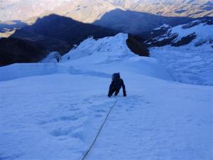
The route wound around crevasses, worked up through penitentes, jogged right, and then left, as we hit the brunt of the upper level winds. Stopping and fidgeting with gear was no longer an option, nor was drinking water or eating. The route crossed a thin crevasse bridge and then steepened to 45 or 50 degrees. Upwards we went, swinging our ice axes and kicking steps steadily into the night, perfect conditions and perfect purchase for the crampons and ax. Finally the route leveled out, crossed a bergschrund and climbed steeply again to the summit ridge, just as the rosy fingers of dawn were starting to bathe the upper mountain in pink light. The full force of the wind and spindrift hit us.
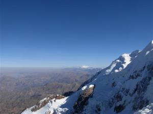
For the first time I began to think, this is enough. I can see the other side of the mountain, a headache is coming on, and the trek to the summit would surely be unpleasant in these conditions. But many winters of summits in the White Mountains of New Hampshire prepared me for this, and I dug a little deeper, knowing that the wind and cold are only temporary, and that we had the necessary gear and energy to proceed. We put our heads down and trudged along the summit ridge into the rising sun, topping out four hours after leaving the high camp, in time to see the mountain cast a long shadow out across the Altiplano. At this elevation it felt like we were flying over the landscape, the earth curving away to the north to Titicaca, to the west to the famous salt flats of Uyuni and the Bolivia’s volcanic range behind them, and a sea of clouds to the east over the Amazon. Two minutes was about all one could stand on the summit before heading back down.
And down was where the careful climbing really began. Now I could finally see the steepness of the terrain we had steadily worked our way up in the dark. Belays would be necessary in places, and we shivered as this side of the mountain remained in the shade until we were only an hour above high camp. Finally, we could slow down and enjoy some of the sun’s warmth, admire the landscape, massive fluted faces, giant crevasses and icefalls, and the brown of the Altiplano in the distance.
While I felt strong for the entire climb, getting back to high camp I suddenly realized the effects of altitude on my body. I chugged as much water as I could and immediately fell asleep for an hour in my tent, before packing and pushing down to 15,000 ft. where a full recovery would be easier. Comparing Illimani to northwest peaks is tough. I would say the route from high camp was slightly steeper than standard routes on Rainier, but slightly shorter timewise, otherwise quite similar. The climate of Bolivia is undoubtedly colder and drier than the northwest, with only about 2m of snow falling per year. Consistently cold temps in the high peaks are what allow glaciers to build despite relatively tiny rates of snowfall compared to the northwest. Climate change has not been kind to Bolivia’s glaciers, however. Almost all of the glaciers in the tropical Andes are in rapid recession. Two years ago, for example, the famous snow spine of 19,000ft Huayna Potosi was reduced to a rock scramble for the first time in memory.


I was actually back in La Paz a day earlier than expected, which meant that I had a few days to play with. I talked to Eduardo and we made immediate plans to capitalize on my acclimatization and head out to do another smaller peak as a day climb from La Paz. Leaving at 4 AM from the city and weaving around chunks of cement and piles of gravel and smouldering tires left over from demonstrations over the previous days, we booked it out to a one lane gravel road leaving the highway in a remote part of the Altiplano, and headed for a trailhead in the Condoriri Range, surely one of the most beautiful in the Andes. Our objective was Little Alpamayo, a gorgeous snow cone of a peak, more technical than Illimani with sustained 55-60 degree slopes to the summit, but much lower in elevation, and much warmer temps. Most people spread this climb over 3 days, for a variety of reasons. The scenic beauty of this area is one of them for sure. It was tempting to linger, but we pressed onward and were back in La Paz by nightfall, a highly satisfying bonus to an already spectacular trip. I highly recommend Bolivia to anyone interested in nature and adventure travel. The people are down to earth and friendly, and by Latin American standards this is a sparsely populated country with incredible wildlife and landscapes. Climbing is also spectacular, easily accessible for the most part, and the climbing culture is one of the strongest in Latin America.


